
The four-month monsoon season from June to September accounts for 75 per cent of rainfall in the country.

Rainfall in August is predicted to be below normal (less than 94 per cent of LPA), but the situation is expected to improve comparatively in September, the IMD said.

The southwest monsoon might finally start withdrawing from parts of North-West India over the next three days, signaling the end of its four-month journey over the country that started in June, the India Meteorological Department (IMD) said. However, though the retreat might begin from next week, the rains might not descend quickly, as the met department predicted fresh spells of rains in Vidarbha, Chhattisgarh and east MP on September 21-22 and over Odisha, Coastal areas north Andhra Pradesh and Gangetic West Bengal on September 19-21. "Due to anti-cyclonic flows over northwest India at lower tropospheric levels, dry weather is very likely over west Rajasthan, Punjab, Haryana, Chandigarh and Delhi during the next five days. "Hence conditions are becoming favourable for the withdrawal of Southwest Monsoon from parts of northwest India during next three days," the IMD said.

The rest of Maharashtra was very likely to get rain and thundershowers in isolated places during this period, the official informed.

The eastern and northern parts of Delhi witnessed rain and hailstorm, IMD said.

Mohapatra said there is a 40 per cent chance of a normal rainfall, 22 per cent above normal, 12 per cent excess and 18 per cent below normal.
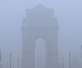
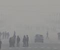
The India Meteorological Department (IMD) reported that very dense fog began forming around 5.30 am, resulting in a thick haze over different parts of the national capital.

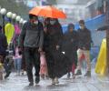
The Indian Meteorological Department has issued a forecast predicting significant precipitation in the city throughout the week, casting a shadow over the series opener.

The Southwest Monsoon usually covers the entire country on July 8. The earlier normal date for the monsoon to cover the entire country was July 15.

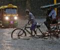
Heavy rains in Bengaluru on Wednesday night resulted in waterlogging, incidents of tree fall, damage to certain infrastructure and power outage in several parts.

The southwest monsoon over the country is likely to be normal in July, the India Meteorological Department (IMD) said on Thursday in its forecast for the month.

The IMD said India did not experience any "break monsoon" conditions this year because of the large number of low-pressure systems.

'The intensity and frequency of heatwaves will be much higher than in previous years over Punjab, Haryana, Rajasthan, Gujarat, Madhya Pradesh and Odisha.'

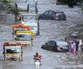
Some low-lying areas like the Andheri subway were submerged, forcing authorities to divert the traffic through alternate routes, civic officials said.

Rains have been 5% below normal so far, but Met department sticks to its forecast

The country can expect normal rainfall during the southwest monsoon season as a positive Indian Ocean Dipole (IOD) and a lower snow cover over the northern hemisphere are likely to counter the evolving El Nino conditions, the India meteorological department (IMD) said on Tuesday.

In another forecast for August, IMD Director General Mrutunjay Mohapatra said monsoon is also likely to be normal in the month.

Mumbai, its satellite cities, north and central Maharashtra and south Gujarat received rains on Wednesday owing to a low-pressure area in the Arabian Sea and a western disturbance, the India meteorological department said.

The southwest monsoon is likely to arrive over Kerala on May 31, a day earlier than its normal onset date, the India Meteorological Department (IMD) said.

The southwest monsoon is set to make its exit in style, bringing rains to the parched parts of Uttar Pradesh and Bihar, as weather forecasters have picked up signs of formation of a cyclonic circulation over Bay of Bengal. Addressing a press conference in New Delhi, India Meteorological Department (IMD) director general Mrutyunjay Mohapatra on Thursday junked last week's forecast of early withdrawal of southwest monsoon and announced the extended stay of the seasonal showers. "Even though we expected early withdrawal of the southwest monsoon, a cyclonic circulation over west-central and adjoining northwest Bay of Bengal will shift the monsoon trough southwards around September 7.

Installed at a cost of Rs 450 crore in Pune and Noida, the two supercomputers are set to fundamentally alter the weather forecasting scenario in India by enabling the IMD to forecast severe weather conditions up to the sub-district or block level.
The minimum temperatures are very likely to fall by 2-5 degrees Celsius over most parts of East India, Central India over the next two-three days, while the spell of intense cold can extend beyond that in the Northwest part of the country.

The minimum temperature in Delhi was recorded at 28.6 degrees Celsius, according to the India Meteorological Department (IMD).

It is in more than a decade that the IMD has predicted 'above-normal' rains in the country.

Mercury hovered around 40 degrees Celsius in large parts of the country on Monday as the Indian meteorological department predicted heat wave conditions in parts of east India over the next four days and the northwest region over the next two days.

The mean maximum temperature for the month of March was 28.2 degrees Celsius in 2020 and 2019. It was 32.8 degrees Celsius in 2018; 30.7 degrees Celsius in 2017 and 31.5 degrees Celsius in 2016, according to the India Meteorological Department data.
Monsoon is likely to be 96 per cent of the long period average

The Met office had said Monday that significantly higher-than-normal temperatures may have an adverse impact on wheat and other crops.

The IMD, in its onset date forecast on May 15, had said the monsoon is likely to hit the southern state on June 5, four days after its normal arrival.
A civic volunteer, identified as Chandan Das (31), died on the spot when he allegedly touched a live wire in Bud Bud in Purba Bardhaman district. The incident happened when he was out with a police team, they said.

The landfall process of the severe cyclonic storm Dana was complete on Friday morning and the system took at least eight and half hours to enter the landmass, India Meteorological Department (IMD) said.

Delhi is likely to receive the first monsoon showers on June 30 or July 1, India Meteorological Department (IMD) officials said on Tuesday.

The IMD had initially predicted that Cyclone Nivar was likely to intensify into a 'severe cyclonic storm' but has now estimated that it will intensify further.
Weather scientists attribute the early onset of southwest monsoon over Kerala to the influence of the remnants of cyclone Asani that triggered the cross-equatorial flow, a key factor for the seasonal rains.

The weather department said its latest model analysis had indicated that the moist easterly winds in the lower level from the Bay of Bengal would spread to northwest India, covering Punjab and Haryana by July 10, leading to the advancement of monsoon and an increase in rainfall activity over the region, including Delhi, from July 10 onwards.

The weather office has issued a forecast of heavy to very heavy rains at isolated places in several districts of Gujarat over the next one week.

The city went under cloud cover and witnessed incessant rainfall from afternoon, with parts of the city witnessing heavy rains and thunderstorms, civic officials said.

The mean minimum temperature for November was 9.6 degree Celsius in 1938; nine degree Celsius in 1931 and 8.9 degree Celsius in 1930, according to IMD data. Normally, the mean minimum temperature for the month of November is 12.9 degree Celsius.

As weather patterns grow more unpredictable due to climate crisis, India is taking a giant leap with "Mission Mausam" to improve weather understanding and forecasting through expanded observation networks, better modeling and advanced tools like AI and machine learning.

Usually, the annual monsoon forecast is released around mid-April.